Over the last century, dams have played a key role in shaping complex social-ecological systems and hydro-political landscapes. With the realities of ongoing urbanization, climate change, environmental degradation, food scarcity, and economic uncertainty, drastic changes need to occur in the way we manage, distribute, and use water. This calls into question the role of spatial practices in imagining productive relationships between dams and the hybrid environments they create. This research focuses on identifying a number of historical precedents and contemporary projects that point towards possibilities of envisioning fluid geographies—modes of practice based on systemic thinking, metabolic relationships, and cross-scalar linkages.
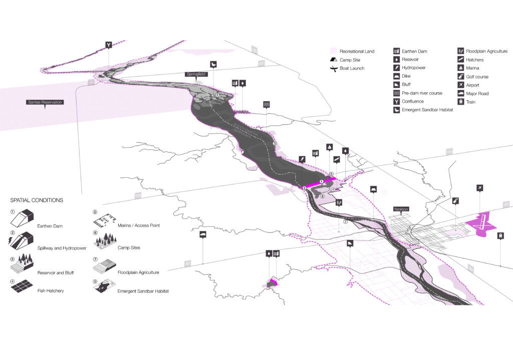
Ongoing research focuses on the Missouri River Basin, arguably the most important watershed of the central United States. The Basin covers over 500,000 square miles and extends across ten U.S. states and two Canadian provinces. Once a wide, shallow and winding river, the Missouri River has been drastically altered during the 20th century for the purposes of flood control, water supply, irrigation, hydropower, navigation, recreation, and fish and wildlife. Recent key events, including the Missouri River Flood of 2011 and record droughts in 2012 have underlined a growing need for stakeholders and policy makers to reevaluate how water is used and managed. The visualizations aim to spatialize existing cultural, environmental and economic forces that are shaping the Missouri River Basin. It points to key sites, events and characters in order to unfold the incongruities, curiosities and paradoxes of the Missouri River Basin’s historic development and its contemporary spatial configuration.
Collaborators
Matthew Bernstine, Elaine Stokes, Liza Miller, Su Zhang, Garrett House, Miyo Takeda